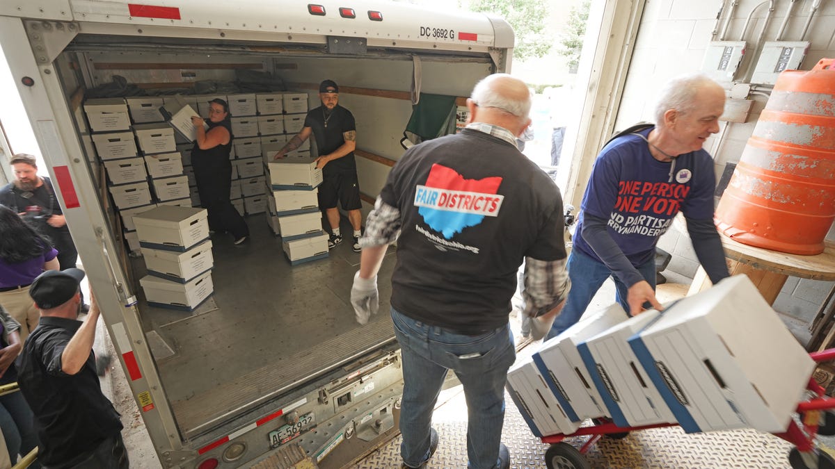
Fed up with politicians manipulating maps to ensure reelection, a crowd of Ohio voters took a key step toward offering a redistricting alternative on the November ballot.
That alternative would replace Ohio’s current system for drawing congressional and legislative maps, which relies on elected officials, with a 15-member panel of Ohioans without close ties to politics.
Honestly, I feel like if districts are gonna be drawn, it’d make more sense to just choose some algorithm and have a computer do it.
Like, if you want to have non-partisan oversight of the algorithm selection, great, but I’m not at all sold that partitioning up the election map requires anything beyond a simple, mechanical process.
reads further
Fed up with politicians manipulating maps to ensure reelection, a crowd of Ohio voters took a key step toward offering a redistricting alternative on the November ballot.
The commission would draw maps that “correspond closely to statewide partisan preferences of the voters of Ohio.” Unlike redistricting proposals approved in 2015 and 2018, this requirement is explicit and mandatory.
If you divide up electoral districts to try to clump similar voters, you kind of guarantee that you’re ensuring re-election. In fact, from past reading, that’s what gerrymandering tends to do. It isn’t primarily that politicians try to get an edge for their party overall. It’s that they try to ensure that they have safe seats without serious competition, even if that ensures that politicians from the other party also enjoy the same situation. Think of an oligopoly, where companies divide up territory or something like that, and each has a monopoly. Like, if you’re going to mandate that under this district-drawing system, what you’re functionally doing is minimizing the power of the public in elections relative to that of incumbent politicians.
Researchers found tactic, widely used in 2020, made little difference in partisan numbers but yielded safe seats, less-responsive representatives
Basically, what gerrymanderers principally aim to do is to reduce how much a politician in an electoral district tends to need to care about what their electorate wants, by eliminating realistic challengers.
One of the most consequential outcomes of this redistricting cycle has been the continuing decrease in the number of competitive congressional districts. Under new maps, there are just 30 districts that Joe Biden won by less than eight percentage points in 2020 and, likewise, just 30 districts that Donald Trump won by less than eight points.
All told, there are now fewer competitive districts than at any point in the last 52 years. If the good news is that both parties emerged with reasonable opportunities in coming years to win control of a closely divided House, the bad news is that they will fight that battle on the narrowest of terrains under maps artificially engineered to reduce competition.
In the end, a closely divided House remains up for grabs, with reasonable opportunities for both parties to win control in coming years. However, barring unforeseen political shifts, most voters will watch that fight from the sidelines due to maps that artificially reduce competition. If Americans hope to reverse the long-term decline of competitive districts, reforms to create fairer, more independent map-drawing processes will be essential.
That’s a good deal if you’re an incumbent politician who wants to be in a position to make use of political influence without being at political risk. But it’s the worst deal you could get in terms of your own influence if you’re a member of the voting public.
Ted Linscott, the retired bricklayer from Athens, said Appalachians tell it like it is: “When we see BS, we call BS and the way our districts are drawn is BS.”
I’m not saying you’re wrong there, dude. But being happy about this proposal is kinda, well…I’m gonna need Gary Larson to help me out on this one.
I feel like a big part of how districts are drawn should involve asking the people which areas are important to them.
It would definitely have to involve some algorithms to sort out and keep the populations roughly equal.
But in general, I kind of envision a system where maybe every 5 or 10 years or so you’d sit down in front of a computer, maybe on election day, or when you renew your driver’s license, or something like that, and you’re presented with a map of your county and the ones that surround it. You select all of the places you live, work, shop, drive through regularly, or otherwise spend most of your time or have particular interests in or concerns about
The computer then draws a district around as many of those points as possible, keeping the population fas even as possible even, and snapping the borders to obvious places- city and county borders, rivers, school districts, major roads, etc.
Then it averages them together into maps that more accurately reflect where the people in those districts actually spend their time.
Pretty big undertaking on the software side, we’d run into the same kinds of issues we do with voting of how to get people to actually show up and fill in their maps, but if we could implement it, to me that seems like the best way to actually draw districts that make sense.
Because I know when I look at the district map where I live, I see a lot of areas included that I have absolutely no connection with, I don’t live there, work there, drive through there, go shopping there, know anyone who lives there, and in general if they burned to the ground today I probably wouldn’t notice for a year or longer, and then there’s other areas where I do spend a lot of time and have other connections to that are not part of my district.
Honestly, I feel like if districts are gonna be drawn, it’d make more sense to just choose some algorithm and have a computer do it.
I’ve thought about this exactly. Here’s my idea.
Crowd source the algorithm every X years. Anybody with basic skills in map making and programming can submit a candidate algorithm. Candidates are scored by…
A) how well they evenly distribute the population across districts (eg +X points for every extra person a district has above a perfectly even distribution), and…
B) how simple the districts are (eg. +Y points for every corner each district boundary has.), which would prevent any kind of gerrymandering.
Lowest score with above example points system wins. Winner gets to have their name on any ballots used while the districts chosen by the algorithm are used. Or something. 🤷
Honestly, I feel like if districts are gonna be drawn, it’d make more sense to just choose some algorithm and have a computer do it.
Like, if you want to have non-partisan oversight of the algorithm selection, great, but I’m not at all sold that partitioning up the election map requires anything beyond a simple, mechanical process.
Agreeing on the algo, its params, etc. is going to just be another never-ending fight. It now also requires teaching any oversight committee about all of this. Even if it were left to some “non-partisan” (I’ll believe it when I see it) engineer, each successive government would just replace the algo and/or engineer.
In my opinion, an algo should be legislated with its implementation forced, but I’m not holding my breath.

Honestly, I feel like if districts are gonna be drawn, it’d make more sense to just choose some algorithm and have a computer do it.
Like, if you want to have non-partisan oversight of the algorithm selection, great, but I’m not at all sold that partitioning up the election map requires anything beyond a simple, mechanical process.
reads further
If you divide up electoral districts to try to clump similar voters, you kind of guarantee that you’re ensuring re-election. In fact, from past reading, that’s what gerrymandering tends to do. It isn’t primarily that politicians try to get an edge for their party overall. It’s that they try to ensure that they have safe seats without serious competition, even if that ensures that politicians from the other party also enjoy the same situation. Think of an oligopoly, where companies divide up territory or something like that, and each has a monopoly. Like, if you’re going to mandate that under this district-drawing system, what you’re functionally doing is minimizing the power of the public in elections relative to that of incumbent politicians.
kagis
Yeah.
https://news.harvard.edu/gazette/story/2023/07/biggest-problem-with-gerrymandering/
Basically, what gerrymanderers principally aim to do is to reduce how much a politician in an electoral district tends to need to care about what their electorate wants, by eliminating realistic challengers.
kagis
https://www.brennancenter.org/our-work/analysis-opinion/gerrymandering-competitive-districts-near-extinction
That’s a good deal if you’re an incumbent politician who wants to be in a position to make use of political influence without being at political risk. But it’s the worst deal you could get in terms of your own influence if you’re a member of the voting public.
I’m not saying you’re wrong there, dude. But being happy about this proposal is kinda, well…I’m gonna need Gary Larson to help me out on this one.
https://lemmy.today/pictrs/image/6a694b63-9618-4b6a-a685-a26f1be54bb9.jpeg
I feel like a big part of how districts are drawn should involve asking the people which areas are important to them.
It would definitely have to involve some algorithms to sort out and keep the populations roughly equal.
But in general, I kind of envision a system where maybe every 5 or 10 years or so you’d sit down in front of a computer, maybe on election day, or when you renew your driver’s license, or something like that, and you’re presented with a map of your county and the ones that surround it. You select all of the places you live, work, shop, drive through regularly, or otherwise spend most of your time or have particular interests in or concerns about
The computer then draws a district around as many of those points as possible, keeping the population fas even as possible even, and snapping the borders to obvious places- city and county borders, rivers, school districts, major roads, etc.
Then it averages them together into maps that more accurately reflect where the people in those districts actually spend their time.
Pretty big undertaking on the software side, we’d run into the same kinds of issues we do with voting of how to get people to actually show up and fill in their maps, but if we could implement it, to me that seems like the best way to actually draw districts that make sense.
Because I know when I look at the district map where I live, I see a lot of areas included that I have absolutely no connection with, I don’t live there, work there, drive through there, go shopping there, know anyone who lives there, and in general if they burned to the ground today I probably wouldn’t notice for a year or longer, and then there’s other areas where I do spend a lot of time and have other connections to that are not part of my district.
I’ve thought about this exactly. Here’s my idea.
Crowd source the algorithm every X years. Anybody with basic skills in map making and programming can submit a candidate algorithm. Candidates are scored by…
A) how well they evenly distribute the population across districts (eg +X points for every extra person a district has above a perfectly even distribution), and…
B) how simple the districts are (eg. +Y points for every corner each district boundary has.), which would prevent any kind of gerrymandering.
Lowest score with above example points system wins. Winner gets to have their name on any ballots used while the districts chosen by the algorithm are used. Or something. 🤷
Agreeing on the algo, its params, etc. is going to just be another never-ending fight. It now also requires teaching any oversight committee about all of this. Even if it were left to some “non-partisan” (I’ll believe it when I see it) engineer, each successive government would just replace the algo and/or engineer.
In my opinion, an algo should be legislated with its implementation forced, but I’m not holding my breath.