Best I can find in Canada is in BC. I think you could get longer distances in a few other provinces, but the issue is a lack of roads/destinations in the northern corners, haha.
But that’s crossing a country. Texas is a state. Going from San Diego to Portland, Maine is ~46 hours, and that’s probably not the longest route. There’s also Alaska and Hawaii (no direct roads to the contiguous 48 states), and Florida, that’s just a pretty long route off the top of my head.
Your geography lesson for today is to map 2 routes across the EU and compare them to your statement.
Map the longest route across the continental EU.
Connect the farthest points of France by way of Paris and compare it to the distance between Hawaii and New York. (Hint: Start is in South America or the Caribbean and finish is in the Pacific. )
Lol, I always forget how much random stuff France owns across the globe.
But here’s an overlay of the EU on the contiguous 48 US states from Reddit (doesn’t include Alaska, which is half as big as the whole US). That even gives the EU UK, which is no longer a member state. Alaska is really really big (like more than half the size of the lower 48 states).


All these guys are posting crossing their whole country, but as Texas is one state, it’s fair to say that’s the same as a province.
Shared route From Windsor, Ontario to Kenora, Ontario via ON-401 E.
23 hr 6 min (2,190 km) For the best route in current traffic visit https://maps.app.goo.gl/Jmm9TmKVu79bTANq5
Staying only within Ontario, Canada it takes almost one full day of literally non stop driving.
Best I can find in Canada is in BC. I think you could get longer distances in a few other provinces, but the issue is a lack of roads/destinations in the northern corners, haha.
Does that account for times you have to stop to brawl with a moose?
If you’re brawling with a moose then you’re not a true Canadian. Every Canadian knows the moose wins every time.
This is true. A moose once bit my sister.
Mynd you, moose bites Kan be pretti nasti
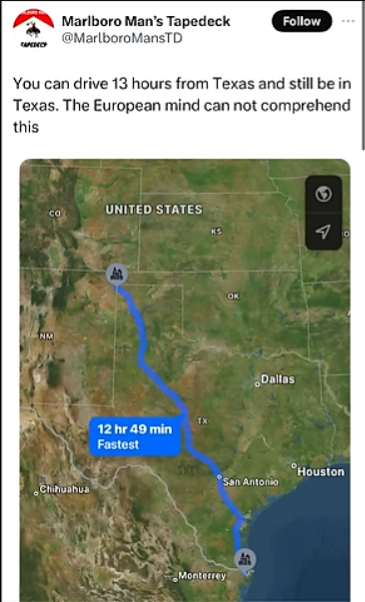
This is in one state.
That is a respectable size and to you sir I can only say what any man can say in this situation.
It’s not about the size, but how you use it. ;-)
Someone travelling from Windsor would almost certainly take the shorter 17hr trip through the states. Still a long one.
The 51st state is part of the USA, that’s the whole point of this post. The Euros just can’t grasp the size.
I guess I missed the /s
Did no one get the 51st state joke…
Your geography lesson for today is (Google) mapping a route from Brest to Menton (France) and compare it to the route posted by OP.
Your history lesson for today is looking up when Canada became the 51st state…and realize I was being sarcastic.
But that’s crossing a country. Texas is a state. Going from San Diego to Portland, Maine is ~46 hours, and that’s probably not the longest route. There’s also Alaska and Hawaii (no direct roads to the contiguous 48 states), and Florida, that’s just a pretty long route off the top of my head.
Your geography lesson for today is to map 2 routes across the EU and compare them to your statement.
Lol, I always forget how much random stuff France owns across the globe.
But here’s an overlay of the EU on the contiguous 48 US states from Reddit (doesn’t include Alaska, which is half as big as the whole US). That even gives the EU UK, which is no longer a member state. Alaska is really really big (like more than half the size of the lower 48 states).
As next lesson you’re going to learn about the failings of the Mercator projection - stay with me you’re going to love this!
While Alaska is pretty massive it is not as big as you think it is. Follow this link to the website that Redditor used to create the visual and drag Alaska onto the rest of the US: https://www.thetruesize.com/#?borders=1~!MTYxNTY4MzI.ODIwNzY1OA*MTA0MzY2ODQ(MzUyODQ4MQ~!CONTIGUOUS_US*MTAwMjQwNzU.MjUwMjM1MTc(MTc1)Mg~!IN*NTI2NDA1MQ.Nzg2MzQyMQ)MQ!CN*OTkyMTY5Nw.NzMxNDcwNQ(MjI1)MA!US-AK*MzU2MjMwMg.Mjg0OTg3OTk)Mw
Next drag Greenland onto Africa and vice versa, then both onto the US. Amazing isn’t it?
This is awesome!!